Boundary Atlas
Free MCP server for US and Canadian boundaries, ZIP crosswalks and GeoJSON
- Pricing
- Free
- Platforms
- API, Web
- Runs
- Remotely
- Version
- 0.2.1
- Listing updated
- 2 days ago
About Boundary Atlas
Boundary Atlas is a free MCP server for maps and travel. It runs as a hosted remote server, so there is nothing to install locally.
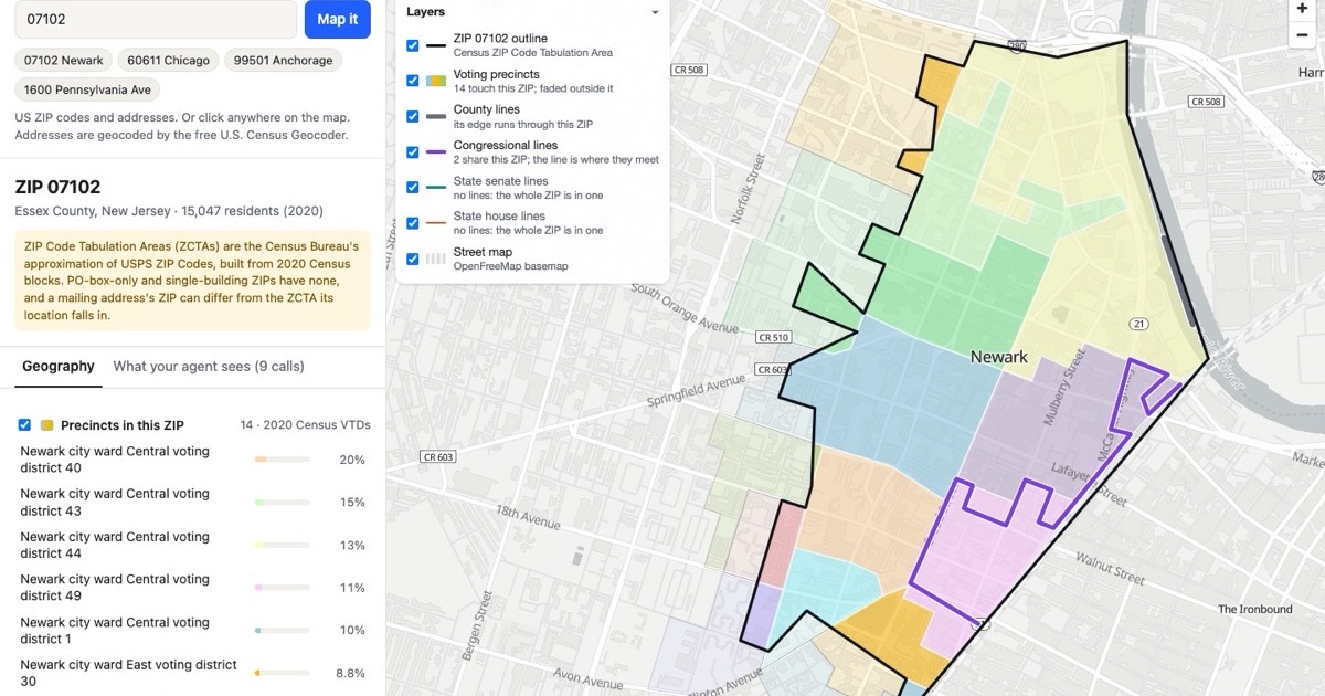
Precision is the selling point here. District maps are the ones in force for the November 3, 2026 election, including mid-decade redraws, and precincts come from current official files covering about 92% of the US population, drawn from 34 statewide files and 437 county, town and municipio sources, with 2020 Census voting districts elsewhere. Canada is covered with provinces, ridings and polling divisions.
ZIP codes rarely line up with cities, counties or districts, so related_geographies returns each overlap with its share of 2020 population. That lets you split a ZIP-level CSV across counties or find which congressional districts a ZIP spans. locate_point does point-in-polygon lookups on boundaries simplified to about 10 m, so a point near a line can land on either side; geocode an address first. get_boundaries returns GeoJSON, with large sets delivered as a download link.
There is no key or sign-up. Limits are 60 requests a minute and 3,000 a day per IP address, and the site says addresses are not stored.
Install
Run in a terminal
claude mcp add --transport http boundary-atlas https://boundarymcp.com/mcpAdd to Settings → Connectors → Add custom connector
https://boundarymcp.com/mcpAdd to ~/.cursor/mcp.json
{
  "mcpServers": {
    "boundary-atlas": {
      "url": "https://boundarymcp.com/mcp"
    }
  }
}Add to .vscode/mcp.json
{
  "servers": {
    "boundary-atlas": {
      "type": "http",
      "url": "https://boundarymcp.com/mcp"
    }
  }
}
Add to ~/.codeium/windsurf/mcp_config.json
{
  "mcpServers": {
    "boundary-atlas": {
      "serverUrl": "https://boundarymcp.com/mcp"
    }
  }
}
Add to your client's MCP settings (most use this shape)
{
  "mcpServers": {
    "boundary-atlas": {
      "type": "http",
      "url": "https://boundarymcp.com/mcp"
    }
  }
}
Tools this server provides (11)
Taken from the project documentation; the running server may differ.
- search_geographies
- Finds geographies by name.
- get_geography
- Full record for one geography with parents, child counts and source.
- list_children
- Geographies directly under a given geography.
- list_geographies
- Every geography at one level, optionally within a state or province.
- related_geographies
- Overlapping geographies with population shares.
- find_officials
- Who represents a place, with contacts.
- locate_point
- Geographies containing a point.
- get_boundaries
- Polygon boundaries as GeoJSON.
- nearest_geographies
- Closest geographies to a latitude and longitude.
- data_freshness
- When each upstream dataset was last fetched and checked.
- coverage_summary
- Row counts and vintage by country and level.
What it does
- Point lookups
- Find the precinct, county, district and city containing a latitude and longitude.
- ZIP crosswalks
- Split ZIPs across cities, counties and districts using population shares.
- GeoJSON boundaries
- Draw any city, county, district, ZIP or precinct, at three detail levels.
- Officials lookup
- Find the House, Senate, state legislators and mayor for a place.
- Source tracking
- Each record shows its source, licence, vintage and last fetch time.
- Local government sites
- Official websites for 15,000+ cities, towns and counties.
Good for
- Assign leads or field teams by county or district
- Roll ZIP-level sales data up to counties with population weights
- Find who represents an address for advocacy work
- Draw a precinct map coloured by congressional district
- Check whether boundary data is overdue for refresh
Pricing
Free
Free, no key or sign-up; 60 requests/minute and 3,000/day per IP
Prices change. Check boundarymcp.com before you buy.
Boundary Atlas FAQ
Do I need an API key?
No. It is Streamable HTTP with no authentication or sign-up.
What are the rate limits?
60 requests a minute and 3,000 a day per IP address.
How current are the district maps?
They are the maps in force for the November 3, 2026 election, including mid-decade redraws.
How accurate is a point lookup?
Boundaries are simplified to about 10 m, so a point within that distance of a line can land on either side.
Is Boundary Atlas free?
Yes. Boundary Atlas is free to use.
How do I add Boundary Atlas to Claude Code?
Run this command in your terminal: claude mcp add --transport http boundary-atlas https://boundarymcp.com/mcp
What are the best alternatives to Boundary Atlas?
The closest alternatives to Boundary Atlas are Agent-Native Analytics, Google Ads + Meta Ads + SEO/GEO MCP, Tapetide - Indian Stock Market MCP, World Monitor and CompanyData.
Alternatives to Boundary Atlas

Agent-Native Analytics
MCP serverOpen-source analytics app where an AI agent builds charts and dashboards from your data
- Remote
- Open source
- 7.7K GitHub stars
- Analytics and data

Google Ads + Meta Ads + SEO/GEO MCP
MCP serverHosted MCP connector for managing Google Ads, Meta Ads, GA4 and Search Console from chat
- 8 tools
- Remote
- Freemium
- 8.1K GitHub stars
- Marketing and SEO

Tapetide - Indian Stock Market MCP
MCP serverIndian NSE and BSE stock market data for AI assistants through 48 MCP tools
- 17 tools
- Remote
- Freemium
- 150 GitHub stars
- Finance and payments

World Monitor
MCP serverLive geopolitical intelligence dashboard with an API and MCP server for agents
- Remote
- Freemium
- Analytics and data

CompanyData
MCP serverSearch and enrich company records from official registers via the CompanyData API
- 3 tools
- Remote
- Paid
- 3 GitHub stars
- Analytics and data

Tutu eSIM
MCP serverLive travel eSIM plans, prices and roaming costs for 190+ countries
- 5 tools
- Remote
- Paid
- Maps and travel